Wonasquam Village and the Skywatchers
Discovering Gloucester’s Ancient History
By Mary Ellen Lepionka
July 5, 2023

Brown's Field
So, this was "Wonasquam"! I was standing at the corner of Wheeler St. and Apple St. on Gloucester's Riverview Peninsula, gazing at a rock-ringed pocket park called Brown's Field. Remains of that Pawtucket village undoubtedly lie beneath it. The people living there would have fetched water from the spring-fed pond nearby, its summertime wreath of trees festooned with herons. In summers there would have been 20 or 30 wigwams and around 200 people between Riverview Rd. and the Thurston Point loop that circles another small pond.
The Pawtucket, or Agawam Indians as the colonists called them, would have beached their canoes at Corliss Landing on the Annisquam, home from clamming on Pearce Island or Rust Island, or from collecting marine clays for their pottery at Clay Pit Landing in the Jones River, or from any number of other errands down to the harbor, up Little River, over in Lobster Cove. They would have minded surf nets on Wingaersheek Beach and Coffins Beach and worked the quartz quarries on Goose Cove. They had a ceremonial stone landscape in Annisquam Woods, a burial ground on Adams Hill in the shadow of Squam Rock, and a watchtower at Lighthouse Point where they looked out for enemies coming into Mill River to raid their corn. Their cornfields are under the Middle School and Veteran's Way, Addison Gilbert Hospital, Poplar Street, Cherry Street, Washington Street, along Alewife Brook.
Riverview
The whole end of the Riverview peninsula is the remains of an enormous shell heap, a flattened artificial mountain of refuse representing thousands of years of human occupation. Colonists mined the midden for lime kilns, and engineers later excavated it for fill to support the Andrew Piatt Bridge that carries Route 128 over the Annisquam River. You can still see the shells around the bridge's footings, and shells are still eroding out of people's lawns on Wheeler's Point. Indigenous peoples have been digging clams in the Annisquam estuary since the Middle Archaic Period some 7,500 years ago. The most recent were Algonquians known as the Pawtucket, and it took me a while to find where they lived and where they watched the sky, and all the places where they made their living.
That time began when I chanced to see Samuel de Champlain's map of Le Beauport-Gloucester Harbor in 1606. His map showed 15 wigwams with corn patches ringing the harbor with 200 people, and there was a wigwam on my street. But we were never told anything about "Indians" here. I thought my grandchildren should know something about local Indigenous history. There was a wigwam on their street too. I had just retired in 2012, with background in anthropology and archaeology and had time to investigate.
In the Archives
In the Gloucester Archives I asked for everything they had on "the Indians." The archivist said they had nothing except a manila folder called the Peterson File, mostly containing barely relevant contemporary magazine articles. "There were no Indians here when the English settled," she said. "They had all died out or disappeared. They may have come here at some time in the past, filtering down through the woods to hunt or fish, because arrowheads have been found. But they did not live here. They were only nomads."
Champlain's Map
Hair-raising, jaw-dropping news! I recognized it immediately as a false narrative, no doubt passed down unquestioned over the generations. It did not make sense. Only 17 years elapsed between the Frenchman's visit and the Dorchester Company's landing at what is now Stage Fort Park. Even with devastating virgin soil epidemics, human populations do not go extinct in 17 years. So, who was living in the wigwam on my street? Where did they come from? What were they doing here? Where did they go?
My questions became an obsession and thus began my quest. I started by surveying all the physical evidence I could find. This included all the artifact collections from Cape Ann I could locate near and far in museums, institutes, historical societies, libraries, and private hands. I photo-documented everything I saw and joined the Massachusetts Archaeological Society to make sure I identified, described, and dated things properly.
In the Ground
There is a lot of artifactual evidence. At the Harvard Museum of Archaeology and Ethnology in Cambridge it took me three days to work through all the objects. They have grave goods from Annisquam, decorated ceramics from Ipswich, weavings and cordage from Manchester, and the Matz Collection from a Contact Period site on the Cape Ann Campgrounds on the Jones River Saltmarsh. The Peabody Essex Museum has artifacts from the Bull Brook Paleoindian site and Archaic Period and Woodland Period sites in Beverly, Salem, Gloucester, and Newbury. The Ipswich Museum brought up crates of artifacts for me to see. Among historical societies, the Sandy Bay Historical Society has Marshall Saville's collection of stone tools from Cape Ann, and the Cape Ann Museum has N. Carleton Phillip's collections from Riverview and other local sites. Among private collectors, Tom Ellis has boxes of artifacts from Coles Island in West Gloucester and islands in Essex Bay.
I found other Cape Ann artifacts far from home: the Chadwick Collection in the Robbins Museum in Middleborough, Massachusetts, the Winter collection from Essex Falls in the Peabody Institute of Archaeology in Andover, the Coffin Stream assemblage from Newbury in the Davis Museum in Freedom, Maine. I also read all the abstracts of the state's archaeological CRM (Cultural Resource Management) site reports for Cape Ann at the Massachusetts Historical Commission. The evidence is solid for Indigenous occupation of Essex County over at least the past 12,000 years, and on Cape Ann from at least the Middle Archaic Period, around 7,500 years ago. And Indigenous people clearly were still living here when English settlers established Gloster Plantation. In 2013 I began to publish articles on all the unpublished evidence I was finding on the Indigenous history of Cape Ann.
On Place Names
Other than archaeological excavations and artifact collections, physical evidence includes our surviving Algonquian place names. I collected all the names I could find in Essex County and embarked on a study of Algonquian languages and research done by historical linguists on the Indigenous languages spoken in New England. The Algonquians who were living on Cape Ann at the time of English settlement spoke an ancient form of Abenaki. They called West Gloucester Agamenticus ("Other side of the small tidal river"). Land beyond the confluence of Little River with the Annisquam they called Winniahdin ("In the vicinity of the heights"). Annisquam is from "Wonasquam", a corruption of Wanaskwiwam ("End of the marsh"). Annisquam does not mean any of the other things stated in local histories or Wikipedia. And there are many more examples.
I gathered and traced Indigenous place names from seventeenth-century maps and accounts of explorers and colonists, and to help cipher these names I consulted people engaged in Indigenous language revival programs. Wingaersheek, for example, is most likely a corruption of Wingawecheek, literally "Sea whelks here" (i.e., wampum shells). The bit our histories tell us about Wingaersheek being a Dutch place name is not true. Neither is the bit about John Endicott's surveyors learning the name of Cape Ann from the Indians living at "Wingaersheek". The English were just learning their name for their beach.
Hitting the Books
I then read the local histories, which don't mention any Indians--not even the earliest account, Obadiah Bruen's 1650 copy of Gloucester's Town Book. Local histories written in the nineteenth century include fads and myths and politics, and have a lot of omissions other than Indigenous Peoples. These histories have gone unchallenged and unrevised all this time. The present-day official history and timeline of Gloucester is taken from them.
At this point, I began to read all the relevant primary source accounts I could identify--the direct observations of explorers, merchants, settlers, missionaries, and government agents. I spent time in the state archives trying to read the earliest records of the Massachusetts Bay Colony on badly scratched microfilm, in the Phillips Library of the Peabody Essex Museum rummaging through boxes of handwritten notes by the early ethnologist Frank Speck, and in the archives and vital records of Essex County towns.
In Gloucester I found only two references to "the Indians who live among us"--in the minutes of selectmen's meetings in 1682 and 1684. In the British Library among the papers of King Charles II, I found the earliest reference to the Annisquam River and its village--a pre-1610 report on "Ye Names of Ye Rivers and Ye Sagamores Yte Inhabit Upon Them", which identifies "Wenesquawam" (later transcribed as Wonasquam). I found direct references to the village of "Wonasquam" in eight primary source documents of the 1600s.
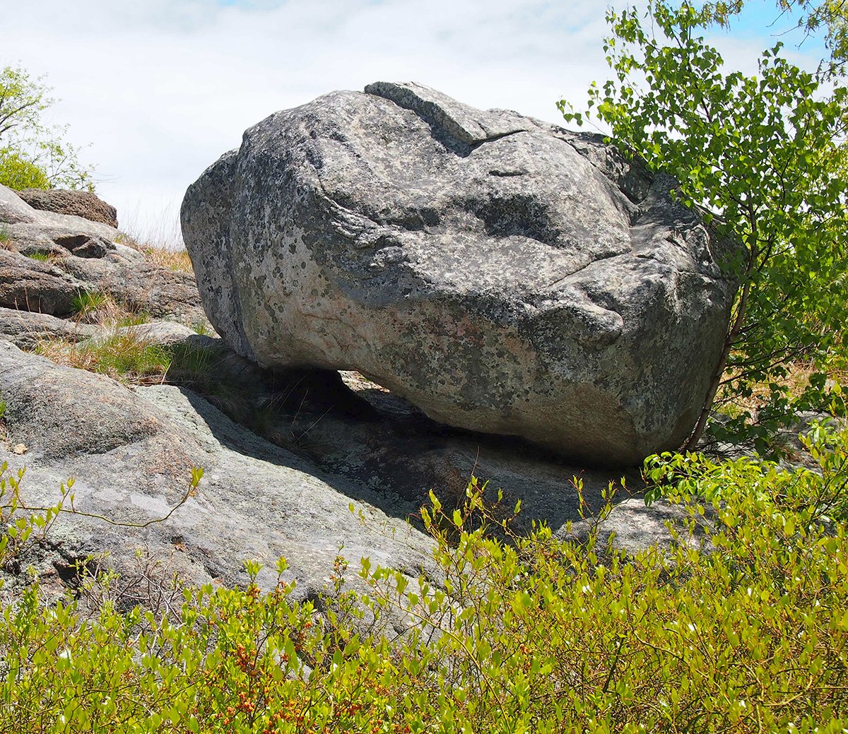
Gnomon
"Aha" Moment
My study of primary source documents extended to historical maps and Indian deeds and treaties. I found a wealth of digitized historical documents online, such as John Endicott's letter to Governor John Winthrop in 1638, saying he had bought "the hoed ground" from the Indians at Cape Ann. In the Salem Registry of Deeds, I found Sagamore Masconomet's two deeds of "Agawam" to John Winthrop Jr. and the quitclaim deed to Gloucester (10,000 acres inclusive of Sandy Bay and Chebacco), signed by Masconomet's grandchildren in 1700.
In the Cape Ann Museum Library, I found a reference to the village of Wonasquam in a transcript of an 1823 account by Ebenezer Pool. This was an "aha" moment, for Pool identified the location--just north of Poles Hill on the Riverview Peninsula. And in the letter book of John Dunton, I found an account of his visit to the "woebegone" Indian village of Wonasquam in 1686 as it was being abandoned by Indians in mourning, streaked with black face paint. And this was that place! I was standing just north of Poles Hill in Riverview, gazing at the site where Ebenezer Pool's grandfather had observed 20 or 30 wigwams in the summertimes, and John Dunton had wondered where the Indians were going and for whom they were mourning.
Up Poles Hill
In the summer of 2013, I endeavored to explore the hill abutting Wonasquam--Poles Hill, owned by the City of Gloucester. Having learned about Algonquian beliefs and ways of life, I knew such a hill would have been culturally significant to any Indigenous people living in and around Wonasquam. Their sagamores would have needed high ground to watch for enemy raiders coming up the river, and their shamans would have needed vantage points for watching the sky. Skywatching is a near universal feature of the Indigenous Peoples of the Americas and of the ancient world in general. For ancient observers, tracking the azimuths (or compass bearings) of events marking seasonal changes was essential for predicting the availability of plants and animals and directing subsistence activities, such as when to lay traps for beaver, when to plant beans, when to fish for sturgeon, when to gather sweetgrass, when to go on pilgrimage, and so on. Sky signs were also needed for conducting rituals, observing ceremonial calendars, and divining the future. I was curious to see if Poles Hill could have been used to watch the sky.
Astronomy 101
Summer Solstice Sunrise Rock
As we learned in school, the seasons are determined by changing amounts of sunlight, determined by the tilt of the Earth’s axis as it orbits the Sun. At the start of spring—the vernal equinox—day and night are equal in length, each approximately 12 hours long. The Sun crosses the equator going northward, rises exactly due east, and sets exactly due west. At the summer solstice, the longest day of the year, the Sun reaches its northernmost point in the sky at noon. After a brief standstill, the days start getting shorter. Fall begins at the autumnal equinox when day and night are again equal in length. The Sun crosses the equator going southward; as in spring, it rises exactly due east and sets exactly due west. The start of winter begins with the winter solstice, the shortest day of the year, when the Sun reaches its southernmost point in the sky at noon. After another brief standstill, the days start getting longer. In astronomical observatories throughout the ancient world, the places on the horizon where the sun rises and sets and hesitates at the start of the four seasons are marked in some way--by poles, stones, landscape features, or architectures of some kind.
Solar and lunar standstills, the changing positions of the planets, heliacal rising and setting of the brightest stars, and astronomical phenomena such as eclipses and meteor showers were also spiritually important. Ancient observatories may mark the appearance of Venus as the morning star and the spiritual guide for people on vision quests. The appearance of Sirius was also important, and the angle at which the Milky Way touches the horizon, the rising and setting of the Pleiades, the rotation of Ursa Major, and more. In Algonquian belief, for example, spirits of the dead can ascend to the sky world on the milky way when it is perpendicular to the horizon. All the stars are ancestors and able to communicate with you. In Indigenous cultures, the whole sky is both sacred and alive.
Ceremonial Time
Consider just significant dates in August in the Algonquian calendar. August 13 marks the half-way point between summer solstice and the autumnal equinox, for example, when the sun again rises and sets at the same points on the horizon. Also, the 12th and 13th of August mark the height of the Perseid meteor shower, regarded by many as malevolent, requiring spiritual protection. That date also brings the setting of the Pleiades, however, which announces the Green Corn Festival and coming harvest. Mid-August is also the time to commemorate the ancestors and the direction of the homelands from which they came, most recently from the north, and for the people before them, from the southwest.
Winter Solstice Sunset
Consider the most important winter observation other than the winter solstice. For Algonquians, the big dipper or Ursa Major is three hunters and their dog chasing a cosmic bear through the circumpolar winter sky. In some versions they wound or kill the bear, its blood causing maple leaves to turn red in fall. In the end, the bear, or in some versions its cub, emerges from its den to begin the cycle again. People in northern New England and eastern Canada conducted an annual winter bear hunt and sacrifice in conjunction with these observations. Could Poles Hill have served such purposes for the Indigenous Peoples of Riverview?
"Eureka" Moment
A track cuts through the plutonic rock between Sunset Hill Road and Riverview Road, bisecting Poles Hill. Entering from the south, I climbed an escarpment to my right, losing a sneaker, banging my camera, dropping my clipboard, and getting my cane wedged in a crevice (I was already an old lady). I came out on a serpentine ribbon of bedrock that led to a big boulder. Another "eureka" moment, for I recognized it immediately as very likely the central marker in an array of stones serving as sightlines to the solstices and equinoxes. I dubbed it the "Gnomon". It had an odd shape and I suspected right away that it had been shaped by human hand in pre-Contact times and positioned to serve as a marker in an astronomical array.
I happened upon this rock in mid-June, near the summer solstice, so I stayed to see where the sun would set. It set over the point of the gnomon, but I could not see the rock or land feature it aligned with because of the secondary growth of trees and shrubs. I needed help. I recruited Mark Carlotto, an engineer and imaging expert, to help find and measure alignments, and Nick Holland and Sandy Barry and other members of the Cape Ann Trail Stewards to clear sight lines.
Several consulting archaeologists, professional geologists, and astronomers also helped in surveying and interpreting the site, along with a host of friends, neighbors, family members, tribal council members, and others. By 2015, with the aid of these experts and volunteers, we learned enough to publish on the subject in the Bulletin of the Massachusetts Archaeological Society. Others continue this work today, although the site is now at risk of losing its authenticity through people's interference with the stones, introduction of new stone features that were never there in the past, and outright vandalism.
The Panther
On the Rocks
Poles Hill is shaped like a shallow oval dish with a false horizon visible from the Gnomon along approximately 290 degrees of rim, on which astronomical objects and events can be observed.
A true horizon is visible in the distance beyond the rim, with a sightline, for example, to the summit of Sunset Mountain in West Gloucester. Using satellite and Google Earth imagery, Mark predicted where sighting stones should be for the solstices and equinoxes and found boulders at or near those positions.
We first found the summer solstice sunrise and sunset sight lines. Summer solstice sunrise rock is a pegmatite boulder uniquely endowed with a lot of pink quartz. Quartz is associated with summer solstice sunrise in other sites of this kind in New England. The summer solstice sunset rock, like other boulders on the site, had been shaped using fire to strike concave spalls from the granite core, later confirmed by the geologists we consulted. We found the winter sunrise stacked boulders and later the winter sunset, which turned out to be the Gnomon's shadow on the rear of the summer sunrise boulder! And we identified the equinox rock, due east of the Gnomon and the highest point on the hill.
The geologists included igneous rock specialists from Boston University and Brown University and a petrologist from Pennsylvania. They had a field day examining the rocks. They told us that the boulders on Poles Hill are from Poles Hill and have always been there. They are glacial erratics dragged back and forth across the bedrock only a few centimeters during each advance and retreat of the ice. The boulders are strongly magnetized, perhaps accounting for the odd sense of disorientation visitors to the hill report.
The geologists confirmed that the boulders in the solar array were shaped by human hand and jockeyed into position, that the Gnomon was shaped by heating the base of the rock with fire and striking off large concave spalls, and that the base was further reduced to provide a layer of sand and grit on which to adjust the position of the heavy boulder. They also showed us how to identify natural chemical and mechanical processes in the weathering of granite to distinguish those from anthropogenic rocks.
Doing the Math
Schematic calendric system
To calculate the alignments between the Gnomon and these boulders, Mark used Google Earth to read the latitude, longitude, and elevation at the center-point of each stone. From these measurements he computed the azimuth angle and elevation angle of the stones from the Gnomon. He used three different Google images to average random errors and provide uncertainty estimates.
When Mark compared the angles with known astronomical positions of the sun, however, they did not align exactly. The sun today rises about eight degrees west of the tip of the summer solstice sunrise rock, for example. This seemed discouraging at first. But then we realized that this discrepancy testifies to the antiquity of the site! Looking at published astronomical tables showing positions of the stars in the past and correcting for atmospheric refraction and the precession of the Earth (its wobbling on its axis), we found that the sightlines would have worked perfectly between 2,000 and 4,000 years ago.
The summer stones were placed first and the winter stones as much as a thousand years later, when agricultural Algonquians began to live here for most of the year. The Poles Hill observatory would have been first constructed around 3,000 years ago by Late Maritime Archaic people, when a bright star called Thuban was the pole star. The site was modified and augmented 2,000 years later by Eastern Woodland people, when the pole star had become Polaris, our north star today.
Mark calculated margins of error and conducted several statistical tests to determine if the boulders in the alignments could have been the result of random placement and/or selection bias. The tests, which are replicable, strongly support the authenticity of the array as a non-random installation. For the first three solstice alignments to occur at random, assuming statistical independence, the probability is on the order of one in a billion. Based on both observation and the math, I am confident that Poles Hill was modified and used by Indigenous Peoples as a calendric system.
Drone photograph
Bird's Eye View
I found I needed to get a sense of the whole hill. I enlisted the aid of drone operators using fixed wing and helicopter drones to try to grasp the site in its totality and identify other possible features. The aerial photographs revealed an extraordinarily complex site and raised a lot of questions. The topography and sheer number of boulders is daunting. Knowing that we could be looking at distortions of random depositions, we nevertheless marked possible features and sightlines in the aerial images to explore and then tried to find them on the ground. We were able to confirm in the aerial photos the solstice and equinox sightlines on the ground and discovered other interesting features as well.
Noted archaeoastronomers surveyed the site and drew our attention to features we had not noticed. They pointed out stone circles, marks cut into the bedrock, partial stone enclosures, intentionally split boulders, wedged bedrock, stone basins with drains, and vantage points for observation called skywatcher seats. One such seat permitted the observation of when the tip of the handle of the Big Dipper would touch the horizon. It was from there that the three hunters and their dog could climb into the sky to begin their chase of the celestial bear!
Wedged bedrock
The archaeologists also identified possible petroglyphs and petroforms--spirit rocks in classic themes for Indigenous New England: the Manitou stone, the whale, the wood bison, the bird, serpent symbology and the horned serpent, and the panther. Panther is a waterworld spirit animal present in Indigenous folklore throughout the Western Hemisphere. It’s also known as the jaguar, cougar, mountain lion, lynx, and polecat. The panther on Poles Hill was at one time an upright megalith.
Rewriting History
My research on Cape Ann's "spirit rocks", including those on Poles Hill, was later published in two issues of the Journal of the New England Antiquities Research Association. Research on Poles Hill continues today as others have stepped up to continue the work in places my body will no longer take me. Many thanks to everyone who will have had a hand in this investigation. I hope local history can be changed to truly respect the long and rich Indigenous history of Cape Ann and to acknowledge the Native people who had a village in Riverview and climbed Poles Hill to watch the sky.

Mary Ellen Lepionka is an independent scholar researching the indigenous history of Essex County. Mary Ellen lives in Gloucester as a retired college instructor and author with a Master’s degree in anthropology from Boston University and Ph.D. work at the University of British Columbia. She taught anthropology, participated in archaeological digs, and had a career in publishing as a developmental editor of college textbooks. Mary Ellen’s articles on Indigenous history are published in the Bulletin of the Massachusetts Archaeological Society and the Journal of the New England Antiquities Research Association. Her essays on appear in historicipswich.org, capeannhistory.org, enduringgloucester.com, and capeannslavery.org.

CULTURE FOLIO CONTENTS